
Hunter & Companion GmbH is the developer of the sports and hunting software MyHunt. This app was created specifically to help hunters maintain and construct new hunting areas. Users can create customized photo albums and save their hunting logs using this app. You can go hunting with your pals by using this app to invite them to the hunting locations.
Users have the ability to share their location and hunting experiences with others, in addition to inviting friends to specific hunting regions. Additionally, this app highlights the hunting area’s feed stations, traps, and well-known locations. Users can get knowledgeable about hunting strategies by participating in expert communities and organizations.
Features
- Create and manage hunting grounds
- Save hunting records
- create a personal hunting photo album
- Share location with others
- Share hunting experience
- Highlights feeding places and famous places
- Learn the tactics of hunting
Pros
- Filter area overview
- Reserve points on hunting grounds
- Mark paths and trails through hunting areas
- Create custom points
- Invite friends to the hunting areas
Cons
- In-app purchases
- Limited species
- Hard to use
1) GOHUNT: GPS Hunting Map

GOHUNT LLC is the developer of the map and navigation program GOHUNT: GPS Hunting Map. This program is specifically made for hunters to help them improve their abilities. Hunters may map, scout, plan, and prepare for a hunt with this app. This app’s entire service portfolio is managed by elite technologists and hunters. Users can learn about hunt units, districts, boundaries between private and public lands, and areas where hunting is permitted or prohibited using this app.
2) GoWild Hunting Fishing Outdoor

GoWild is the developer of the social and sports app GoWild Hunting Fishing Outdoor. Outdoor enthusiasts can use this app to track things like heart rate and distance traveled. You can monitor their hunting accomplishments and recollections in addition to their pulse rate and distance traveled. Because of the app’s “shop smarter” feature, you may purchase goods or services from a variety of stores via an e-commerce platform.
3) HuntStand: GPS Hunting Tool

TerraStride Inc. is the developer of the sports tool and app HuntStand: GPS Hunting Tools. This app was created specifically with North American hunters and land management in mind. Users can get offline maps and the weather in hunt regions with the aid of this app. Users of the app can access weather tools and hunting maps. The software contains measurement tools that allow you to measure the in addition to hunting, mapping, and meteorological features.
4) HuntWise: A Better Hunting App

Sportsman Tracker created the sports and hunting software HuntWise: A Better Hunting software. People can maximize their hunting experience by using this app. This software gives customers professional advice on how to increase the efficiency of their hunts. You can track the direction and speed of the wind at all of your pinpoints and tree stands with the help of the app’s WindCast feature. Notifications are also sent to users, allowing them to hit the woods at optimal times.
5) FOOTPATH ROUTE PLANNER
A measuring tool called FOOTPATH ROUTE PLANNER can help you determine the precise length and altitude of your walk. You can use the offline topographic map features to create a route based on turns that meets your needs. To use its maps, you can instantly connect to highways and trails. Additionally, this program elevates the sales and maintains a record of your fingertips through turn-by-turn navigation. It works with the program that lets you control the routes that are predicted with accuracy.
6) IOVERLANDER
A measuring tool called FOOTPATH ROUTE PLANNER can help you determine the precise length and altitude of your walk. You can use the offline topographic map features to create a route based on turns that meets your needs. To use its maps, you can instantly connect to highways and trails. Additionally, this program elevates the sales and maintains a record of your fingertips through turn-by-turn navigation. It works with the program that lets you control the routes that are predicted with accuracy.
7) ONX BACKCOUNTRY: 3D TRIAL MAPS
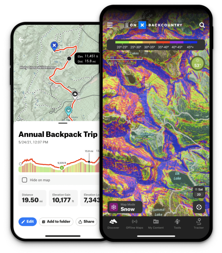
An explorer app called ONX BACKCOUNTRY: 3D TRAIL MAPS helps you on your journey. The feature of straight routes for backpacking and ski tours is offered by this application. The value of informing your pals can assist you in choosing your upcoming adventure. Maps that are accessible from any location can be saved and accessed offline. Moreover, it incorporates GPS functionality into your mobile device even in the event of a network outage.
Our Recommendation
We suggest you to use GO WILD Hunting Fishing App so you can use this app to track things like heart rate and distance traveled. You can monitor their hunting accomplishments and recollections in addition to their pulse rate and distance traveled. Because of the app’s “shop smarter” feature, you may purchase goods or services from a variety of stores via an e-commerce platform.